Inca Trail
The Inca Trail is a walking route that leads through the mountains above the Urubamba river, following (at least partly) the course of an old Inca roadway leading to the ruined city of Machu Picchu.
We started the Inca Trail bright and early on the first day but pretty soon we hit our first problem. The coach was supposed to drive us to KM 88 the official start of the trail. Unfortunately because of heavy rain part of the road had been washed away so we had to walk an extra 10km with both our 5kg packs and day packs just to get to the start. It started raining as well so I was glad I brought my Poncho (very stylish!). We were glad to hand over the packs to the porters at the start of the trail. The first part was relatively easy as it was a pretty flat walk following the river. The porters race on ahead and carry everything from our bags, to the tents and all the camping equipment including one who even carried a gas canister. We had around 30 porters for our group and it was incredible to watch them run up the trail carrying these huge packs - they all wear sandals and just use plastic sheets for protection against the weather. Their pay is relatively low so we all made sure to give them a good tip at the end.
We stopped for lunch by a football pitch and a few of us had a game with the guides which we managed to loose!! Running around you certainly notice a difference in breathing at altitude. The meals were spot on and you could easily forget you were camping - there was a dinning tent with tables and chairs. We walked somemore the first day before arriving at the first camp. When we arrived the porters had set up the tents and had all your stuff ready.
We got woken up early on the second day. I found the morning of the second day tough I was right at the back of the group and was really struggling with my breathing, I probably had eaten too much for breakfast as well (fat cracker!).
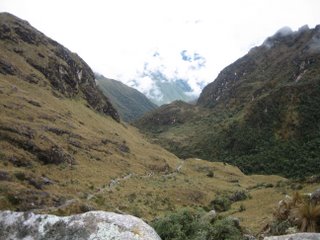
After a tea break I felt a lot better and concentrated on keeping in the middle of the group. We climbed up to the first pass the Abra de Huarmihuanusca ("Dead Woman's Pass")it is 4050m above sea-level and the highest point on the trail. After the Abra de Huarmihuanusca, the trail descended steeply towards the valley of the Pacamayo river. At the bottom of the river valley is the second campsite - we arrived here fairly early in the afternoon and had lunch. We spent the afternoon at the campsite before getting an early night.
From the valley of the Pacamayo, the trail climbed steeply up the opposite side of the valley wall, towards the second pass. About halfway up is a Inca ruin known as Runkuracay ("Pile of Ruins"). The building is thought to have been a tambo, a kind of way post for couriers following the trail to Machu Picchu.
After Runkuracay, the trail continued to climb towards the second pass, the Abra de Runkuracay at 3500m. On the far side of the pass, the trail descended to a valley containing a shallow lake. At around this point, the trail changed from a dirt path to a narrow stone roadway the beginning of the true Inca Trail.

The trail then took us on to a second, larger Inca ruin, Sayacmarca ("Town in a Steep Place"). Sayacmarca effectively controlled the trail. It is built on a rock overlooking the trail accessible only via a single narrow stone staircase.
After Sayacmarca, the trail descended to the valley floor, and the roadway takes the form of a long causeway before the trail begins to climb again. It is hard to imagine how the road was built there is even an 8 metre tunnel section where the Inca engineers widened a natural crack in the rock into a tunnel large enough to allow the passage of men and animals.
The trail then lead us up to the third pass and, just beyond it, a third Inca ruin, Phuyupatamarca ("Cloud-level Town"). From Phuyupatamarca, the trail spirals and descends steeply towards Huinay Huayna, ("Forever Young")the site of another Inca ruin. This was where we stopped on the third day. This campsite had hot showers and a beer both of which were a welcome site.
Unfortunately at this site we received some bad news!!
There had been a landslide which had wiped out the final section of the trail - normally you walk up to the sun gate which looks down onto Machu Picchu but the trail had been so badly damaged that it was too dangerous and had been closed. The whole group was very dissapointed.
So plan B kicked into action we still had to wake up early (4 am) as the porters needed to get the tents back to the start of the trail for the next groups to use. We had to follow the porters down their path which was no easy task in the dark. The porters take the path down and catch a train back to Cusco but we had to walk along the tracks to Aguas Calientes where we could take a bus up to Machu Picchu - fortunately we were still some of the first tourist groups to get there and although it did not make us feel much better it was cloudy which meant we wouldn´t have seen much from the sun gate.
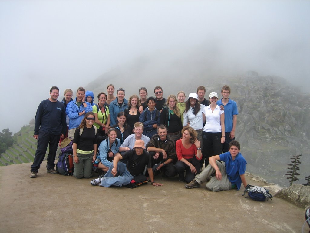
Here´s a shot of Machu Picchu (and my poncho!) and one of the group at the end.


Machu Picchu itself is incredible however we learned that it is sinking and may not be there in 30 years time.
You can really see what the city may have been like - there are terraces for agriculture, storehouses, all kinds of temples - an altar for sacrifices and even orchid gardens.
Well I was exhausted by the time we made it to the end (as I bet you are if you´ve read all this entry!). We got the bus back to Aguas Calientes and went to the natural spas there to soak our muscles before heading back to Cusco.
We started the Inca Trail bright and early on the first day but pretty soon we hit our first problem. The coach was supposed to drive us to KM 88 the official start of the trail. Unfortunately because of heavy rain part of the road had been washed away so we had to walk an extra 10km with both our 5kg packs and day packs just to get to the start. It started raining as well so I was glad I brought my Poncho (very stylish!). We were glad to hand over the packs to the porters at the start of the trail. The first part was relatively easy as it was a pretty flat walk following the river. The porters race on ahead and carry everything from our bags, to the tents and all the camping equipment including one who even carried a gas canister. We had around 30 porters for our group and it was incredible to watch them run up the trail carrying these huge packs - they all wear sandals and just use plastic sheets for protection against the weather. Their pay is relatively low so we all made sure to give them a good tip at the end.
We stopped for lunch by a football pitch and a few of us had a game with the guides which we managed to loose!! Running around you certainly notice a difference in breathing at altitude. The meals were spot on and you could easily forget you were camping - there was a dinning tent with tables and chairs. We walked somemore the first day before arriving at the first camp. When we arrived the porters had set up the tents and had all your stuff ready.
We got woken up early on the second day. I found the morning of the second day tough I was right at the back of the group and was really struggling with my breathing, I probably had eaten too much for breakfast as well (fat cracker!).

After a tea break I felt a lot better and concentrated on keeping in the middle of the group. We climbed up to the first pass the Abra de Huarmihuanusca ("Dead Woman's Pass")it is 4050m above sea-level and the highest point on the trail. After the Abra de Huarmihuanusca, the trail descended steeply towards the valley of the Pacamayo river. At the bottom of the river valley is the second campsite - we arrived here fairly early in the afternoon and had lunch. We spent the afternoon at the campsite before getting an early night.
From the valley of the Pacamayo, the trail climbed steeply up the opposite side of the valley wall, towards the second pass. About halfway up is a Inca ruin known as Runkuracay ("Pile of Ruins"). The building is thought to have been a tambo, a kind of way post for couriers following the trail to Machu Picchu.
After Runkuracay, the trail continued to climb towards the second pass, the Abra de Runkuracay at 3500m. On the far side of the pass, the trail descended to a valley containing a shallow lake. At around this point, the trail changed from a dirt path to a narrow stone roadway the beginning of the true Inca Trail.

The trail then took us on to a second, larger Inca ruin, Sayacmarca ("Town in a Steep Place"). Sayacmarca effectively controlled the trail. It is built on a rock overlooking the trail accessible only via a single narrow stone staircase.
After Sayacmarca, the trail descended to the valley floor, and the roadway takes the form of a long causeway before the trail begins to climb again. It is hard to imagine how the road was built there is even an 8 metre tunnel section where the Inca engineers widened a natural crack in the rock into a tunnel large enough to allow the passage of men and animals.
The trail then lead us up to the third pass and, just beyond it, a third Inca ruin, Phuyupatamarca ("Cloud-level Town"). From Phuyupatamarca, the trail spirals and descends steeply towards Huinay Huayna, ("Forever Young")the site of another Inca ruin. This was where we stopped on the third day. This campsite had hot showers and a beer both of which were a welcome site.
Unfortunately at this site we received some bad news!!
There had been a landslide which had wiped out the final section of the trail - normally you walk up to the sun gate which looks down onto Machu Picchu but the trail had been so badly damaged that it was too dangerous and had been closed. The whole group was very dissapointed.
So plan B kicked into action we still had to wake up early (4 am) as the porters needed to get the tents back to the start of the trail for the next groups to use. We had to follow the porters down their path which was no easy task in the dark. The porters take the path down and catch a train back to Cusco but we had to walk along the tracks to Aguas Calientes where we could take a bus up to Machu Picchu - fortunately we were still some of the first tourist groups to get there and although it did not make us feel much better it was cloudy which meant we wouldn´t have seen much from the sun gate.
Here´s a shot of Machu Picchu (and my poncho!) and one of the group at the end.

Machu Picchu itself is incredible however we learned that it is sinking and may not be there in 30 years time.
You can really see what the city may have been like - there are terraces for agriculture, storehouses, all kinds of temples - an altar for sacrifices and even orchid gardens.
Well I was exhausted by the time we made it to the end (as I bet you are if you´ve read all this entry!). We got the bus back to Aguas Calientes and went to the natural spas there to soak our muscles before heading back to Cusco.
posted by Phil at 9:50 PM
![]()
![]()

2 Comments:
This blog entry was well worth the wait - even though it was cloudy it looks fantastic. Poncho also looks cool (if that's possible!). Definately a place that I want you to take me to ;-)
Jen
x
Hi Phil
Looks like you're having a good time, I particularly like the poncho.
Will you be spending some of your time in a tee pee?
Charlotte
Post a Comment
<< Home